
Plans unveiled for 1,450 homes, school and cemetery in Harborough
A development of 1,450 homes, a school and a cemetery is on the cards for Market Harborough.
If approved, the homes will be built on two sites, one east of Harborough Road and the other south of Gallow Field Road.
The information has come to light because Hallam Land and William Davis Homes have asked Harborough District Council (HDC) whether they need to carry out an environmental impact assessment (EIA) – which evaluates the potential environmental impacts of such schemes – before moving forward on the proposed development.
The two parcels of land in question are known as site A and site B. Documents note that site A is 111.88 hectares and site B is 30.67 hectares, making a total of approximately 142.55 hectares.
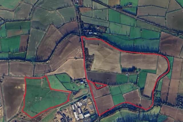

Planning documents submitted to HDC state that site A sits on land to the east of Harborough Road, would have approximately 850 new homes, either a primary through to secondary school, or separate primary and secondary schools, a mixed use local centre, land for cemetery provision, a temporary agricultural showground and formal and informal public open space. New vehicle, cycle and pedestrian access, and other supporting infrastructure would be included, they add.
Lying to the north, south and east of site A is the Grand Union Canal. The B6047 Harborough Road is on the western side, and Leicester Lane runs east-west through the centre of the site, plans note.
Site A is currently agricultural land. In the centre of the northern part of the site are two houses and some farm buildings.
Site B, on land south of Gallow Field Road, would have approximately 600 new homes and formal and informal public open space. Again, new vehicle, cycle and pedestrian access, and other supporting infrastructure would be included, the applicant has said.
Land with planning permission for commercial development is on the eastern side of site B, and to the south is the northern boundary of the Airfield Farm development, noted as currently under construction. To the west lies agricultural land and beyond that is HMP Gartree, the applicant states.
Site B is currently mainly grassland, according to planning documents, and part of it is used as a temporary showground for agricultural events.
A decision date on the EIA query is not listed on the HDC website.